Sunday, August 30, 2009

Forest History Center

For the past three days we have been just outside Grand Rapids, Minnesota at a Corps of Engineers campground. It was a little noisy right off US 2, but the campground is right on the Mississippi River. Ron, rebel that he is, had no problem pulling in, rather than backing in like everybody else, so we had a great view of the river out the front window.

We had some cold and rain early on. I have to wonder if we came north a bit late in the year. I snapped this of our hardy neighbors - it made me laugh seeing them all bundled up determined to enjoy their fire. Of course I bet they were talking about us staying inside.


Ron even had to break out his 'cookie monster' slippers to stay warm.


But we did have a nice sunset.


Saturday was still cool, but a gorgeous day and we headed out to the Forest History Center. Besides a nice visitor center, they have a recreated turn-of-the-century logging camp populated by colorful characters.

We saw the bunkhouse - two to a bunk.


And the outhouse - just line up on the log.


I loved the cook - never trust a skinny cook.


And this guy was in charge of caring for the all-important saws.


He had the kids demonstrate the two-man saw. These two were really cute.


We happened to attend on 'Real Horsepower Weekend' so we got to see lots and lots of horses. They demonstrated how valuable these horses were in the 1900 lumber industry.


There was a serpentine course to demonstrate how the horses could drag the logs through the woods. Somehow I don't think the work horses were quite like these gorgeous matched Percherons.


Ron tried his hand at freeing a log jam.

Interestingly enough, logging was only done in winter. They would freeze the logging roads and use sleds to move the logs. Ron had a uncle who went up to the 'North Woods' and participated in this industry.

Here's a picture from the visitor center.

Thursday, August 27, 2009

The Twin Ports

We spent the last two days in the sister cities of Duluth, MN and Superior, WI, nicknamed the Twin Ports. I don't know what I expected, but it wasn't the thriving seaport and clean, prosperous cities we toured. But that just shows how little I know. The harbor is the world's farthest-inland seaport and over 1100 vessels drop anchor there each year during the April-December shipping season.

Following the recommendation of our friends who we ran into in Bayfield, we took the 1 1/2 hour harbor boat tour. It was fantastic and very reasonably priced. The narration was very informative with silly jokes thrown in for people like me who appreciate them.

Here we are about to go under the High Bridge. Counter-balanced by 450 ton concrete weights in the towers, the 917 ton roadway is raised just enough for us to pass underneath.


The town of Duluth is picturesque as we glide out of the harbor and onto Lake Superior.


Out of all the information we received on our tour, I found two things particularly fascinating. First, this just looks like another 1000 foot ship, right?


But no, the Presque Isle is actually a tug/barge combination. If you look closely, you can see where the tug fits into a notch in the barge and can be disconnected.

I thought that was incredibly clever, but I guess I'm alone in my opinion. Our tour guide said it was the only one like it ever built.

As for the other interesting fact, we learned the aforementioned High Bridge was the second version to be built. The first was a gondola built in 1905. Both Ron and I looked at each other and asked, "Did he just say gondola?" I couldn't picture that at all, but luckily the Corps of Engineers visitor center had a model. (The original is in black with the new bridge in silver.)

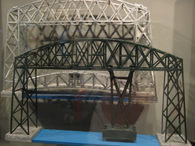
The gondola or transfer car carried up to 62 1/2 tons including automobiles, horses and wagons, and pedestrians. It took about 2 1/2 minutes to cross the 300 foot wide canal. In 1930 it was replaced with the new lift bridge, using major structural elements of the original bridge. How thrifty!

While we were in the COE visitor center, a ship came through the canal into the harbor. This one was only 730 feet long, but still pretty impressive. Look at all the tourists on a Tuesday!


Of course, I had to get a shot of it going under the bridge which they lifted to its maximum height (138 feet) for this baby.

The area around the canal for several blocks has obviously been through urban renewal. The old warehouses have been renovated with shops and restaurants and the place is jumping! I was very impressed.

On Wednesday, after we did our five loads of laundry, we stopped at the Superior library to see their 35 murals. Completed in 2002 by Ojibwe artist Carl Gawboy, they depict local history from the Ojibwe story of creation. . .


To the shipwreck of the Edmund Fitzgerald in 1975. . .


With lots of gorgeous scenes of the years between.

(I know this is getting long, but we're almost done.)

We also drove Skyline Parkway along the ridge overlooking the town and climbed Enger Tower for the optimum view. That's Duluth way down there with another ship about to pass through the canal.


And this is what I didn't understand. On the other side of the canal, separating Lake Superior from the harbor, is miles of what I can only think of as a sandbar with houses! Lots and lots of houses! That doesn't seem too safe to me right on the lake like that. One of the locals told us they've never had a problem, but that wouldn't reassure me.


And another load of whatever begins its journey across the Great Lakes.

Tuesday, August 25, 2009

The Apostle Islands

As I mentioned in the previous post, the Apostle Islands are just off the northernmost tip of Wisconsin in Lake Superior. All but one of the 22 islands (Madeline being the exception) have been set aside as a National Lakeshore, along with 12 miles of shoreline on the mainland. Why 'Apostle?' you ask when there are 22 of them? The answer is nobody knows. They were probably named by the early French trappers and who knows what they were thinking.

Neither of us had ever been there before, so we wanted the whole experience. At 9:30 on Monday morning we arrived in Bayfield and picked up our tickets for the Grand Tour around the islands. Although the tour didn't leave until 10, the good seats were already taken, and by that I mean the ones by the open windows. I'm sure I annoyed people by sticking my camera out their windows, but I do have a responsibility. This map shows our route with the yellow dotted line.


Unfortunately, we didn't have perfect blue sky like the day before, but plenty of sun anyway. The islands range in area from 3 to 10,054 acres and in height from 10 to 479 feet above lake level. They are heavily forested with some of the remote islands never having been logged.

Here is Honeymoon Rock on the northeast side of Basswood Island. Not the place I would pick for a honeymoon.


Some of the islands and the lakeshore are riddled with sandstone seacaves. Since Lake Superior is known for violent storms, you can imagine the wear on the cliffs. Devils Island, the most northern island, has the most interesting cliffs.


And this is the Raspberry Island lighthouse. The light here first operated in 1864 and the dwelling was built later.

The captain had a lot of good information and stories, but I'm afraid I can't remember enough details to repeat any of it. However here are my tips if you decide to take this cruise. If you want the upper deck, reserve days ahead. The upper deck didn't have a cover and we didn't really want to sit in the sun and 20 mph wind (that's how fast the boat goes) for 3 hours anyway. However we were told the wind wasn't bad and most people don't try to avoid the sun like we do. Lastly, board just as early as you can for optimum seating and we thought the port side of the boat was the better side (we lucked out on that one.)

We stopped at the National Lakeshore visitor center where I checked out how I would look as a ranger. Wow! Those exercises really seem to be working. Look at that build!


The town of Bayfield had some really gorgeous houses. Like this one, most have probably been converted to B&Bs.


After the cruise, we hiked two miles through the woods to see seacaves along the mainland shoreline. We were told the best way to see them is to come in February and hike on the ice along the shoreline. Ron and I agreed that's not going to happen.


Here are some seacaves if you look hard enough. Although the water appears calm in this picture, there was a lot of slapping and crashing going on down there.


Ah, there's a cave.


Although I had expected the hike to be more along the lake, you can see why that wasn't the case. It's amazing how the waves formed these deep ravines that we had to hike around.

While we were admiring the view, we realized it was getting late and we were meeting some good friends for dinner. Practically running, we did the two mile return hike in 33 minutes. Peggy and Marvin (the expert WIN hikers) would be proud.

Yes, indeed, even in the tiny town of Bayfield, Ron managed to run into people he knows. How does he do it? We had a terrific dinner (fine food, great company) at a marina just south of town.

Sunday, August 23, 2009

Madeline Island

Madeline Island is the largest of the Apostle Islands located off the northernmost tip of Wisconsin. Madeline is the only one of the Apostles that is not part of the National Lakeshore, so that means ferry service, roads, souvenir shops and fudge. I had the brilliant (?) idea to take our bikes over and ride around the island. Unfortunately, I didn't calculate the mileage of our planned route and it was a bit much for me. By the end my legs hurt so bad that I told Ron if I ever suggested biking again, he should just shoot me. Just so you can laugh at my physical prowess, or lack thereof, it came to 15 miles total. Pathetic, huh?

The weather couldn't have been more beautiful - highs in the mid-70's and a few puffy clouds in a gorgeous blue sky. We loaded the bikes and ourselves on the ferry for the speedy 30 minute, 2.6 mile trip to Madeline Island.


The ferry dropped us off in La Pointe and we immediately saddled up and rode off. I did stop for this shot of a cute little church for my friend Iveytrails who always finds the picturesque churches.


As you can see, the road was freshly paved for smooth riding. This was probably the closest I ever got to Ron. In fact I would have lost him completely if he hadn't waited for me.


Our goal was the Big Bay State Park where we walked out on the beach and I tried to hold the camera with my shaking hands. If it's a little blurry, you understand.


Ron got a shot of me as I bravely smiled on our return trip.


I do have one tip for anybody who wants to bike to the state park. There are three roads you can take. We went out on the Big Bay Road which had very few glimpses of the lake through the trees. Our return was on Middle Road which was nicer and even had a bike lane. (Actually since the lines hadn't been painted yet, it was just a wide road, but nice.) I think the 'road not taken' was probably the best - South Shore Road. Ask before you go.

Here's a stretch along Middle Road that paralleled the shoreline.

Now for the good news, on the returning ferry ride, Ron discovered he had an Ibuprofen with him and within 1/2 hour my legs were fine. And here I thought I was going to have to resort to wine. Although I don't usually talk about restaurants, we asked at the ferry for a suggestion and they sent us to Maggie's in Bayfield. What a cute place - all decorated with flamingos and whatnot and with very good food. Our waitress had worked there for 25 years which I think is as long as it's been open.

Saturday, August 22, 2009

More Wisconsin

Lest you think I never offer anything educational, Ron and I went to see the world's largest ginseng root at Hsu's Ginseng in Wausau. At 2.04 lbs, this root holds a Guinness World Record. And at $200 a pound, Ron and I are going to start combing the woods for ginseng! Here's the prize specimen preserved in vodka!

Here's my question, if vodka can be used as a preservative, why does it destroy peoples' livers?

Here's Ron holding the model so you can get an idea of the size.


Also in Wausau, we were impressed by this collection of gasoline signs. This picture was taken four days ago and was the last time we would see blue sky until today.


So what we saw was a lot of this. . .


On Thursday, we arrived at Two Lakes CG, a lovely National Forest CG in northern Wisconsin. It sits between two lakes, Owen and Bass, and has sites big enough for Bob and Donna's 40' RV plus 30' trailer!

When we arrived, the first thing we did was unhitch and take the car to all 95 sites, looking for the perfect one. Isn't this what everybody does? In our case, we look for sun for the solar panels and, if possible, a clear view of the southern sky for the satellite TV. When I explained this to the campground host, he said he had never heard of somebody doing that. "Really?!?," I exclaimed incredulously. However I noticed that they had satellites for both TV and internet.

After waiting out the rain and cold (did we come north too late?), today we awoke to gorgeous sunshine and this lovely view out the front window.


Trying to make up for lost time, we hiked the trail around Bass Lake in the morning and dusted off the kayaks and kayaked it in the afternoon.

We saw a Kingfisher and lots of Yellow-Bellied Sapsuckers. (That name always makes me laugh.)

And this guy who seems to be asking, "Are you looking at me?"

Monday, August 17, 2009

Scenes from Wisconsin

We're still hanging around in Wisconsin. Ron's been working on genealogy, we attended his high school reunion, had dinner last night and tonight with two more of his 35 cousins and we're meeting his best childhood friend for lunch tomorrow. We really have to eat some leftovers soon - the refrigerator is bursting at the seams.

I promised the cousins I wouldn't post their pictures so I'll post a couple of the more unusual sights we've found.

Somebody really takes their football seriously!


We loved this little Winnebago Brave we saw at Sams Club. It's no longer than a car.


Driving along the road, we keep looking for the sandhill cranes that we understand are in the area. Although the sandhills have been elusive, we did discover this rare red crane and managed to get a shot of it.

Just look at that long, graceful neck!